|
|
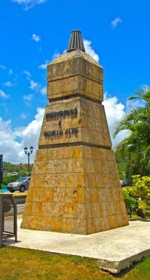
Trujillo Alto
Situated on the eastern side of the San Juan Metropolitan Area, Trujillo Alto stretches South from Carolina and San Juan down to the borders of Gurabo and Caguas. Founded in 1801 as the municipality of Trujillo, it suffered from disagreements amongst its resident as to the location of the church and town centre, which eventually led to a split into the separate town's of Trujillo Bajo and Trujillo Alto.
During the seventeenth century, Spanish colonists began settling on both banks of the Cayrabón river ( as it was called by Tainos and known now as the Río Grande de Loíza). During that time, the Spanish Crown granted Alonso Pizarro Hermona, who came to Puerto Rico from the town of Trujillo in Spain, a large tract of land that extended over both banks of the river.
|
|
Welcome to Trujillo Alto.
|
As happened in many parts of the world, the area became known as Trujillo, named after the founder's original home.
By 1793, residents of Trujillo went to the Bishop and to the Governor of Puerto Rico to request permission to build a church in order to receive mass, and to group houses around it so that, once there was a sufficient number of residents, the town could be founded formally as a municpality.
As a main justification for this petition was the serious flooding of the river, which for many weeks at a time made it impossible for the people to travel to Río Piedras to attend mass and receive communion. The request was opposed by residents of the West bank of the river because, if the town was established on the East side of the river, they would be unable to reach it during the floods. However, the residents of Dos Bocas, Quebrada Grande, Quebrada Negrito and Quebrada Infierno were able to sustain the argument that they had a larger population, so establishment of the town centre and church on the East side was approved in the location where the Trujillo Alto downtown area still exists today. On January 8, 1801, the new municipality was founded as "Santa Cruz de Trujillo".
During the years from 1801, the residents on the West and East banks of the river continued to disagree on the location of the church and town centre. When the church was eventually constructed by 1817, the West bank barrios seceded and formed the town of Trujillo Bajo. By 1820 the name of the remaining part of the original town was changed from Trujillo to Trujillo Alto to distinguish it from Trujillo Bajo.
Access to Trujillo Alto improved in 1826 when two bridges were built to link the town with Río Piedras and with Río Grande. These bridges reduced the effect of flooding of the river on travel to and from the town. In 1844 the existence of the municipality was consolidated with the construction of the Casa del Rey, followed within ten years by the first school in the town.
In 1902 the town, as with a number of others around the island, was subject to a new law consolidating municipalities, and Trujillo Alto was absorbed into Carolina. This was reversed in 1905 and Trujillo Alto has remained its own municipality ever since.
It was not until 1910 that the town had the space destined to house the Plaza de Recreo. In that same year, work began on its construction, with the erecting of a masonry wall 15 meters long and 7 feet high. This work was completed in 1913, and consisted of sidewalks, walls, walkways, and benches.
Trujillo Alto originally developed with ranches raising cattle and with farming, but in recent years has expanded rapidly as a dormitory town for San Juan. The expansion of housing and associated commercial enterprises has made for a large population growth but Trujillo Alto has deliberately made the effort to maintain its roots and traditions and still has as one of its nicknames, the "City in the countryside".
|
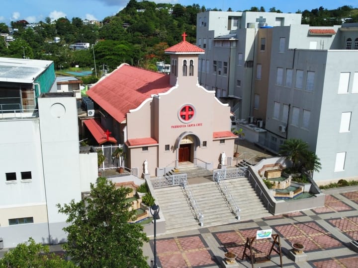
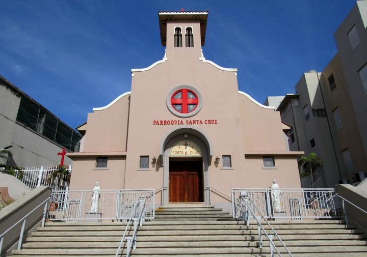
Exaltación de la Santa Cruz Parish Church
While the building of a parish church was one of the requirements for the founding of a municipality in colonial Puerto Rico, it took some years to construct the church of the municipality of Trujillo. Arguments amongst residents as to where to locate the church were part of the problems which caused the municipality of Trujillo to split into Trujillo Alto and Trujillo Bajo, which happened around the time the church was completed.
|
|
Exaltación de la Santa Cruz
|
Many records are lacking to give dates with confidence about the church construction and its name, but it appears to have finally been completed in its initial form between 1814 and 1917, some years after the formal creation of Trujillo as a municipality in 1801. That its construction was in masonry is confirmed by one report from 1829 during a visit to the parish by Bishop Gutierrez.
The church was rebuilt in concrete in September 1928 following its damage by Hurricane San Felipe and the current façade dates back to 1956. The church continues to sit at the centre of the West side of the Plaza de Recreo, flanked by buildings belonging to its associated school (Colegio de la Santa Cruz).
The church is dedicated to the Exaltación de la Santa Cruz (Exaltation of the Holy Cross), though there is no evidence to confirm that this was authorised. The two bells in the bell tower, are named Anna and Maria, and are dated from 1900 and 1928 by inscriptions on the bells themselves.
HISTORY OF THE CONSTRUCTION OF THE PARISH CHURCH
Seven years after the municipality was founded, the residents of Trujillo were still waiting for the construction of their parish church. On January 9, 1808, Bishop Juan Alejo Arizmendi made a pastoral visit to the town, choosing on that occasion the site where the parish church should be built. Near the end of the same month, on January 27, Governor Toribio Montes ordered the selection of an appropriately skilled architect to take charge of the design of the church. However, two main problems prevented progress - a lack of sufficient funds, and a lack of cooperation from the residents of the lower part of the town (West of the river).
Don Pedro Díaz, Teniente a Guerra (War Lieutenant) of the upper part of Trujillo (East of the river), proposed that a temporary wooden building be erected in order to make progress. In addition, he managed to gather several neighbors to deal with the matter, including Don Lino María Valdejulli, a man of prestige who lived in the Candelaria neighborhood.
By the next year, there had still been no progress. On October 29, 1809, Díaz wrote the following to the new governor Salvador Meléndez Bruna: "Trujillo does not even have the chapel that existed where they used to celebrate the divine offices." He attributed this lack of progress in building the new church to the fact that: "Everyone wants to have the temple on the threshold of his house."
In early 1814, the construction had still not been completed, but work was underway with Díaz continuing to lay blame on the lack of cooperation of the municipality of Trujillo, which was controlled by the residents on the West side.
By the end of 1814 it seems that the church was finished, being erected in the same place where it resides today, as chosen by Bishop Arizmendi. The first evidence that mentions its name, the Holy Cross, was in 1816 when Father Fray Manual García Serrano, handed the parish over to its new priest Fray Antolín de Caldas.
|
|
View from the Plaza de Recreo
|
The following year, minutes of the town council establish that the church had been built and that a chapel had been rebuilt. Pedro Tomás de Córdova, in his work Memoirs, states that the church had been erected by that date (1817) and was established in honor of the Holy Cross.
In 1829, Bishop Gutierrez's report on his visit to Trujillo Alto, said that the church was good, made of masonry, covered with wood and tiles, and had regular ornaments.
Finally, there are reports of attempts to build a new, larger and more solid church from 1844, something that would not succeed until the early 1850s.
|
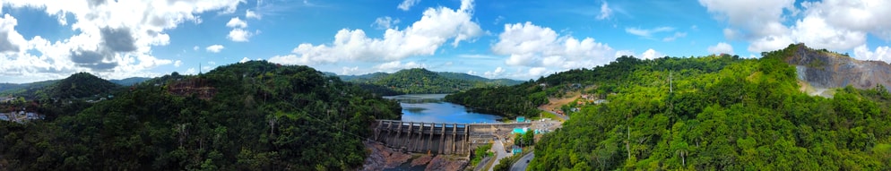
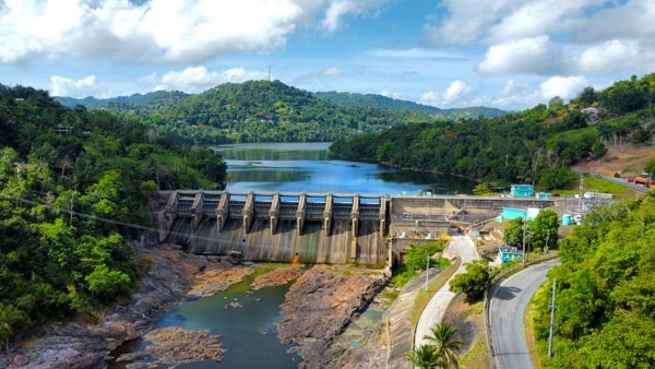
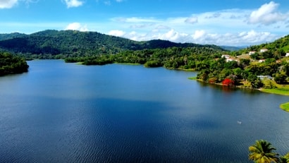
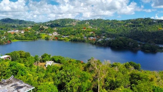
Carraizo Dam and Lake Carraizo
With a growing demand for water in San Juan and surrounding towns at the end of the 1940's, the Aqueduct and Sewer Authority proposed the building of a dam on the Río Grande de Loíza. The location they proposed for this dam was in Trujillo Alto's Barrio Carraízo. The damming of the river at this point was expected to create a lake which would be a reservoir of sufficient size to meet the demands for water in San Juan. Additionally, installation of water turbines within the dam were proposed for the generation of electricity.
|
|
Carraizo Dam with the Lake stretching out behind
|
Construction of the dam started in the early 1950s and was completed in 1954. The dam itself is 215 meters long and rises 27 meters above the riverbed. It contains 8 gates that are designed to open at a height of one meter up to 10 meters in order to control overflow from the lake. The maximum height of water in the reservoir behind the dam is 41.15 meters and provides a water storage capacity of 4,650,000 gallons.
|
|
Lake Carraizo from its West bank below Quebrada Carraizo
|
As originally proposed, the dam included three hydroelectric turbines with a capacity to produce 3 megawatts of electricity. The use of these turbines was discontinued in the 1960-70s, when it was decided that it was not cost effective to run these, as was the case for a number of such small generation plants around the island. During Hurricane Hugo in 1989, the waters of Lake Carraízo overtopped the dam and the resulting internal flooding rendered the hydroelectric facility inside the dam inoperable. A restoration project was initiated in 2013, but Hurricane Maria in 2017 again caused overtopping of the dam and the current status is unclear.
|
|
Lake Carraizo from its East bank looking back towards the Dam
|
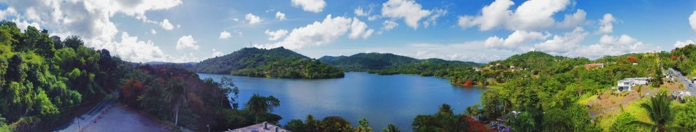
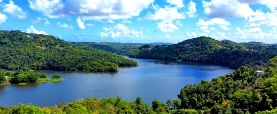
The reservoir created by the dam covers an area of about 1,000 acres and stretches South through Trujillo Alto into the municipalities of Gurabo and Caguas. Within Trujillo Alto, the lake covers land in barrios Carraízo and La Gloria, reaches through barrios Celada and Rincón in Gurabo and into San Antonio, Río Cañas and Bairoa in Caguas.
|
|
Looking down on the Lake close to the borders with Gurabo and Caguas
|
The reservoir is fed principally from the Río Grande de Loíza and its tributaries: the Caguitas, Bairoa, Cañas, Gurabo and Quebrada Infierno. It covers an area of 421.7 hectares and has a capacity of 24.7 cubic hectometers with an average depth of 8.5 meters and has a maximum depth of 29.5 meters. With a drainage area of 533 square kilometers, Lake Carraízo is the largest reservoir in Puerto.
In addition to any fish that lived in the rivers, other species have been introduced from fish nurseries to make Lake Carraízo a destination for those interested in recreational fishing.
|
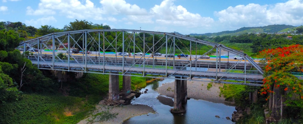
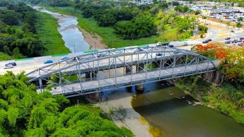
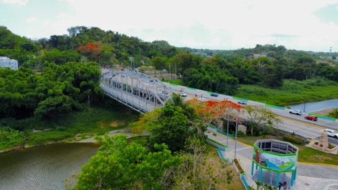
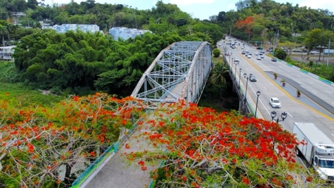
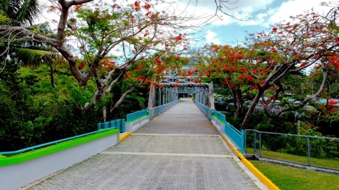
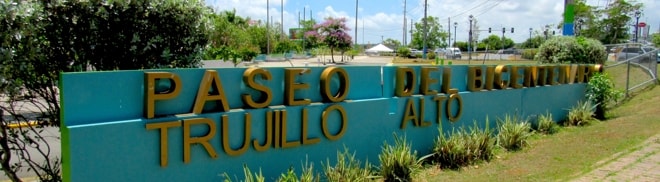
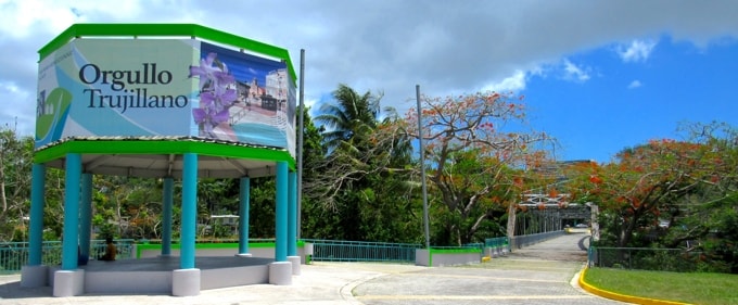
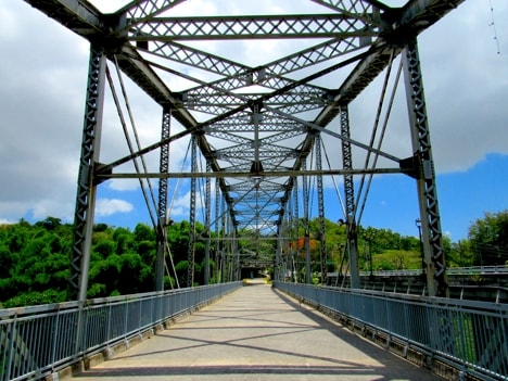
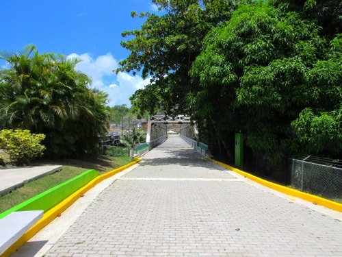
Historic Bridge and Bicentennial Promenade
The Historic Bridge at the entrance to the downtown area has been, and remains today, a landmark of Trujillo Alto, even after its use by vehicular traffic was transferred to a more modern concrete bridge. Since 2007, it has been joined with the Paseo del Bicentenario (Bicentennial Promenade) and, as a walkway, has become an extension of the Promenade while retaining its own iconic place in the town.
|
|
During Construction in 1940 Photo Source: National Register of Historic Places
|
|
|
Entrance to Paseo del Bicentenario
|
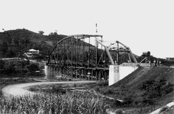
Despite the road from Rio Piedras to Trujillo Alto being the main access to the town throughout its history, the crossing of the Rio Grande de Loiza at the town entrance had seen a number of bridges over the years, all of which had suffered due to the frequent, severe flooding of the river. In 1936, the concrete bridge then in place was destroyed by flooding and the need to keep the road open saw a temporary wooden bridge built on the surviving piles of the concrete bridge. This wooden bridge proved difficult to maintain and studies began in 1938 for a new bridge that could provide the necessary vehicular access to the town and survive the natural elements.
|
|
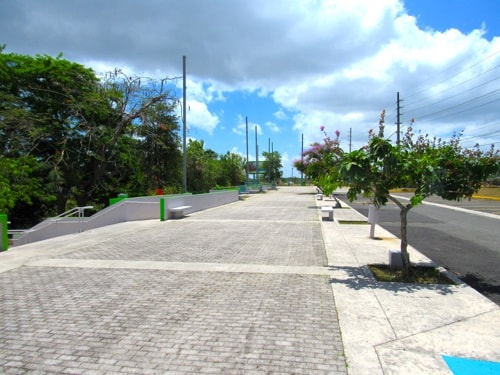
The Bicentennial Promenade
|
With the signing of a contract for a new steel bridge in 1939, work then began with the clearing and preparing of the area. This steel bridge was designed as a Pennsylvania through truss bridge, with construction of its foundation starting in early 1940 and it was completed in 1941. This new single span steel bridge, with a span length of 101 meters and a total length of 102.3 meters, became the longest bridge of its type in Puerto Rico. Following its opening to traffic in 1941 it was the primary access to Trujillo Alto and remained so until it was replaced by a modern concrete bridge carrying a 4-lane highway in 1985.
|
|
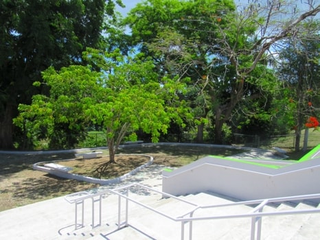
A quiet area below the main promenade
|
Initially destined for demolition following its replacement, the people of Trujillo Alto raised objections based on the bridge's historic importance and their claim that it was an iconic landmark in Trujillo Alto and Puerto Rico as a whole. Plans for demolition were cancelled and later, between 2002-2004, a restoration project was carried out to shore up the worn abutments, replace missing steel parts and repair the deck.
|
|
The promenade leads onto the bridge
|
In 2003 the municipality approached the Puerto Rico Road and Transportation Authority with a proposal to build a promenade on the southern end of the bridge at the entrance to the traditional downtown area in commemoration of the municipality's 200th anniversary. This proposal was agreed to and the bridge was incorporated as a pedestrian walkway, with coordination of the paving on the restored bridge's deck being matched in the new promenade. The Paseo del Bicentenario (Bicentennial Promenade) was opened in 2007 with the restored bridge as an integral part.
|
|
On the Bridge
|
|
|
Looking back across the Bridge to the Promenade
|
While the construction of the new concrete bridge at its side had some effects on the historic bridge, and the restoration and integration into Paseo del Bicentenario made changes to its decking to ensure a safe pedestrian walkway, the bridge has retained its essential style and engineering design and its place as an icon of Trujillo Alto.
More views of the Bridge
|
Other scenes from around Trujillo Alto
Casa Cultura
|
|
Casa Cultura
|
La Casa de la Cultura (House of Culture), located in the downtown area on Muñoz Rivera Street, houses the municipality's offices of the Department of Education, Arts, Culture and Tourism.
|
|
Bandera de Hector
|
|
Bandera de Hector
|
Trujillo Alto has the 54th edition of the Bandera de Hector, which can be found on the side of the School of Arts' Dance building.
|
Antigua Casa Alcaldía
|
|
Antigua Casa Alcaldía
|
|
|
|
|
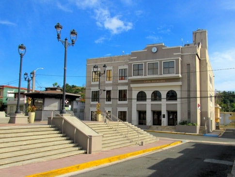
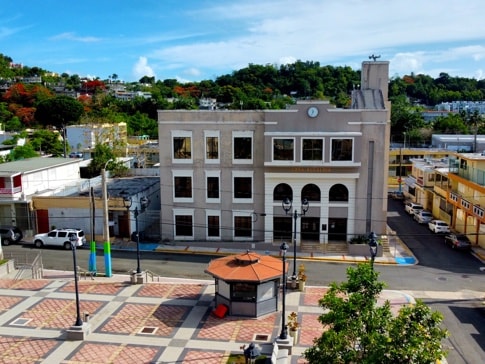
Antigua Casa Alcaldía sits at the North end of the Plaza de Recreo
|
|
|
The Antigua Casa Alcaldía sits at the northern end of the Plaza de Recreo. This building was opened in 1928, and served as the Casa Alcaldía from then until 2006. It was remodeled in 2012 when it was reinaugurated and dedicated to former mayor, Elsie Calderón Rodríguez. In its current incarnation it houses various offices of the municipal government, including: Community Development, Citizen Services, Housing, the Municipal Alliance of Integrated Services and the Office of Services for People with Disabilities.
|
Other views around the Plaza de Recreo
|
|
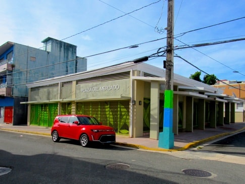
Plaza del Mercado
|
The Plaza del Mercado (Marketplace) sits on the corner of Calle José Gonzalo Diaz and Calle Dr. Fernández.
|
|
|
|
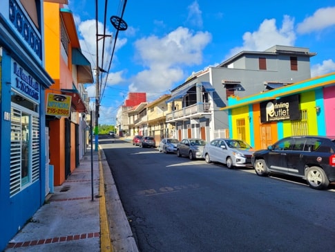
Downtown Trujillo Alto
|
A view looking up Calle Muñoz Rivera, a block East of the Plaza de Recreo.
|
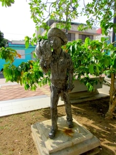
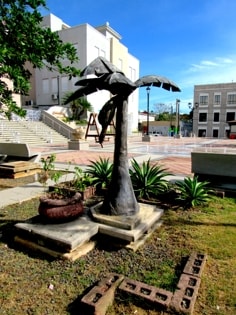
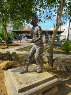
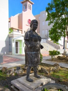
Sculpture Garden in the Plaza
|
|
|
|
|
|
|
|
|
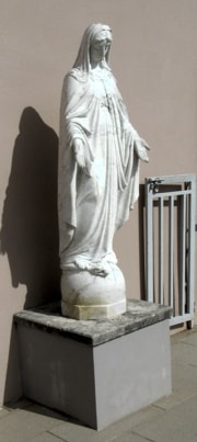
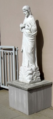
Towards the southern end of the Plaza de Recreo is a sculpture garden, laid out with a number of indivdual statues spread out amongst trees and bushes, which together represent a scene of "typical" Puerto Rico.
|
|
|
|